What are geologic structures?
Geologic structures, such as faults and folds, are the architecture of the earth’s crust. These structures are the rock’s response to stress. Stress, the forces that cause the rock to deform, results in the rock undergoing some form of bending or breaking, or both.
- If rocks tend to break, they are said to be brittle. If a rock breaks, it is said to undergo brittle behavior.
- If rocks tend to bend without breaking, they are said to be ductile.
- If a rock bends but is able to return to its original position when the stress is released, it is said to undergo elastic behavior.
- If a rock bends and stays bent after stress is released, it is said to undergo plastic behavior.
(Dawes, R.)
What are folds?
Folds are ductile rocks that behave plastically and commonly become folded in response to stress. The most basic types of folds are anticlines and synclines.

Anticlines are “up” folds having the oldest rocks exposed in the middle.
Synclines are “down” folds where the youngest rocks are found in the middle of the fold.
What are faults?
A fault is a break in the earth’s crust along which movement can take place causing an earthquake. There are three main types of faults:
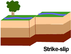


Image Source: USGS, Public domain, via Wikimedia Commons
The Wasatch fault
The Wasatch fault is active today, with at least 19 major earthquakes documented along the fault over the last six thousand years (UGS, 1996). Although there have been no recent large movements along the fault, evidence of potentially catastrophic earthquakes are well preserved in glacial sediments at the mouth of Little Cottonwood Canyon. These fault scarps are so distinctive that they are frequently pictured in geological and geophysical textbooks. They are easily observed from G. K. Gilbert Geologic Park located at the corner of Wasatch Boulevard and Little Cottonwood Road.
Movement along the Wasatch Fault is believed to have begun approximately 20 million years ago. Movement rates are extremely rapid in geologic terms, estimated by the Utah Geological Survey to be as much as 130 feet over approximately 16,000 years (UGS, 1996). That equates to an inch of uplift every 10.25 years, which far exceeds the erosion rate. (Source: Alta Historical Society)
Click here for more information about faults
Click here for more specific information about the Wasatch Fault
Explore this interactive map, produced by the Utah Geological Survey, containing information on faults and fault-related folds considered to be potential earthquake sources. The faults and folds in the database are considered to have been sources of large earthquakes (about magnitude 6.5 or greater) during the Quaternary geologic time period (past 2.6 million years); these geologic structures are the most likely sources of large earthquakes in the future.
